Why Your Phone Map Needs Einstein
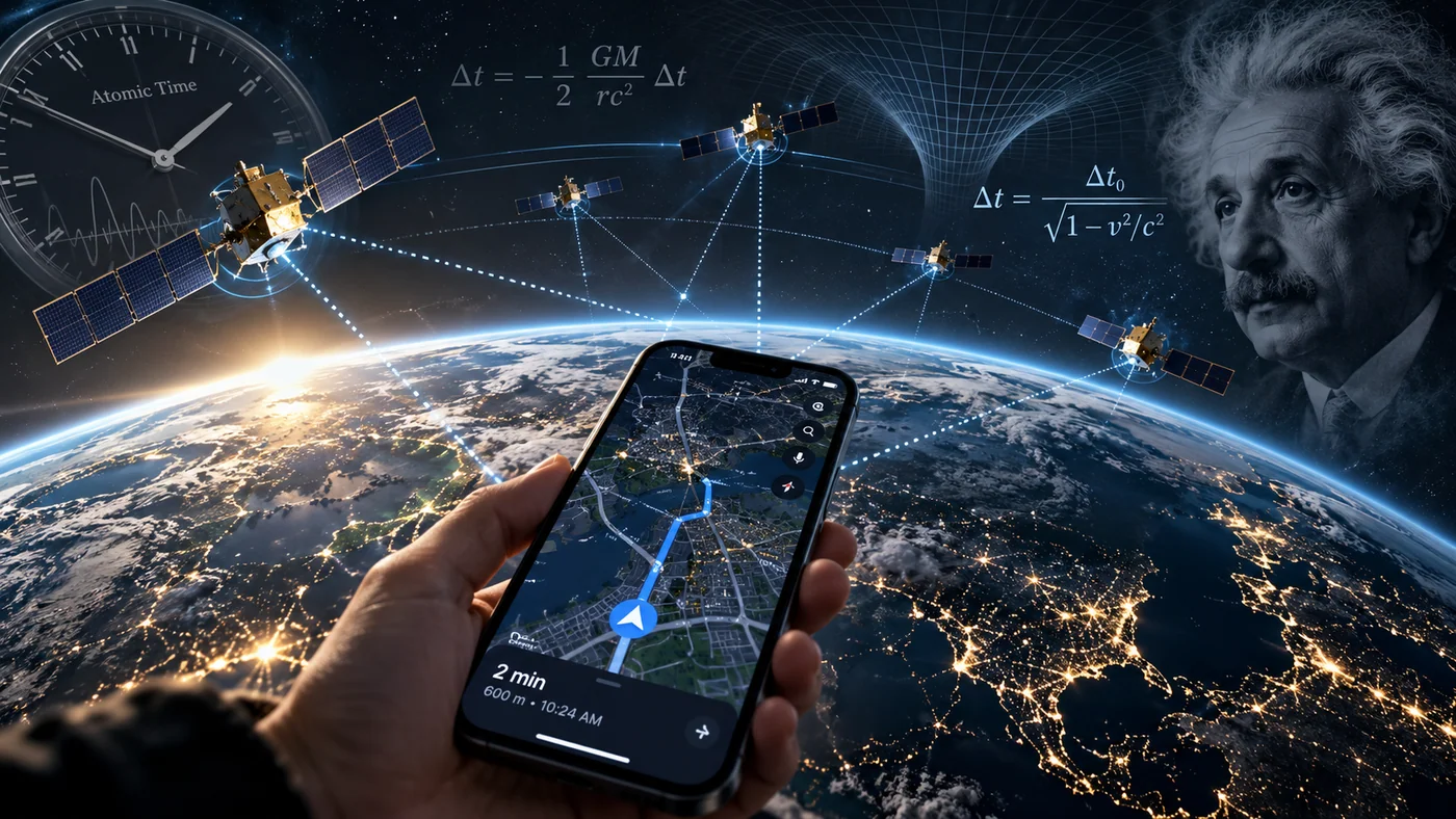
You open a map, type an address and watch the blue dot find its place on Earth. It feels like a picture of the world arriving from space. In reality, your phone is solving an extraordinarily delicate problem about time - and two predictions made by Albert Einstein are built into the answer.
Your blue dot begins with a radio signal
A GPS satellite continuously broadcasts signals carrying precise timing and orbit information. Your phone does not ask the satellite to look down at your location; it listens. The receiver compares when a signal was transmitted with when it arrived, then uses the travel time of that radio signal to estimate a distance to the satellite. That estimate is called a pseudorange because the receiver’s own clock error is part of the measurement [1].
Radio waves travel at roughly the speed of light, close to 300,000 kilometres per second in a vacuum. A timing error of just one microsecond is equivalent to about 300 metres of signal travel. Smaller errors still matter when a navigation app is trying to guide someone to the correct side of a street or the correct entrance to a building.
Four satellites are typically needed for an independent solution: three coordinates of position and one unknown clock offset. This is the clever part. Your phone need not carry an expensive atomic clock. It calculates and continually corrects its time offset using signals from several satellites whose positions and clocks are already known accurately [1][2].
Why the satellite clocks are so important
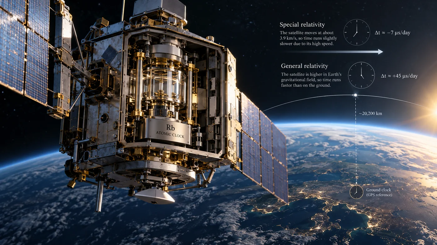
GPS satellites carry atomic clocks, instruments that use stable atomic transitions as a reference for measuring time. The clocks are extraordinarily accurate, but they are not isolated from the laws of physics. The satellites fly around Earth at an altitude of about 20,200 kilometres and travel fast enough that even tiny relativistic effects become operationally important [2].
The ground receiver needs more than a clock reading. It also needs the satellite’s orbital information and compensation for delays caused by the ionosphere, troposphere, signal reflection and receiver hardware. A location is computed from several imperfect measurements whose errors must be modelled and reduced.
This is why it is better to describe GPS as an engineered timing and ranging system rather than “a map in space”. The familiar moving dot is the visible result of an invisible agreement among clocks, mathematical models and radio receivers.
GPS works because it measures time with astonishing precision, not because satellites take pictures of your street.
Einstein’s two effects pull in opposite directions
According to special relativity, a clock moving relative to a reference ticks more slowly. A GPS satellite travels at several kilometres per second, and that motion makes its onboard clock lose about seven microseconds per day compared with an Earth-based reference clock. The number sounds negligible until you recall how quickly light covers ground [3].
General relativity introduces a different effect. Time runs at different rates in different gravitational potentials. Far above Earth’s surface, the satellite experiences weaker gravity, and its clock runs about 45 microseconds per day faster than a comparable clock on the ground. Combining the two effects gives a net gain of approximately 38 microseconds per day for an uncorrected satellite clock [3].
Those figures are well-established approximations for GPS. They do not mean that your phone would be misplaced by exactly the same distance every day; a real navigation solution depends on satellite geometry, errors and correction mechanisms. The important point is that the timing drift is large enough to ruin accurate positioning if engineers ignored it.
The remarkable arithmetic behind 38 microseconds
For a sense of scale, light travels around 11.4 kilometres in 38 microseconds. That is the distance corresponding to the time discrepancy in the simplest one-way ranging interpretation - not a direct statement of GPS position error. The distinction matters because navigation is calculated from several satellites, not one stopwatch.
Engineers account for the main relativistic effects in the frequency and timing design of the satellite system, and receivers apply other corrections as part of their navigation calculations. Relativity is not a clever add-on placed over a finished map; it is part of the physics the system has to respect before a reliable map position can exist.
Consider the contrast. The underlying equations were developed for understanding space, time and gravity. Today their consequences are handled routinely by devices in pockets, cars and delivery vans. GPS is one of the clearest examples of fundamental science becoming everyday infrastructure.
The people on the ground still matter
In orbit, satellites provide continuous signals. On Earth, monitoring stations and control facilities keep track of satellite orbits, clocks and the health of the constellation. They measure the system’s performance and upload updated navigation information. GPS.gov describes three connected segments: space satellites, a ground control network and the billions of user receivers that calculate position and time [1][4].
Without this control network, a satellite clock could still tick, but information about where the satellite actually was - and the accuracy of its timing - would become increasingly uncertain. Navigation depends on knowing both the clock and the location of the signal source. Neither measurement can be guessed away.
This dependence on ground systems is a useful reminder that “space technology” is often a blend of orbital engineering, terrestrial networks and very ordinary operational routines. The great achievement is not a single satellite. It is the system staying coordinated day after day.

Why a map can still put you on the wrong street
Even with relativity correctly accounted for, satellite navigation is not perfect. Tall buildings can block signals or reflect them into a receiver after a longer journey. Trees and tunnels reduce visibility. Conditions in the atmosphere affect radio propagation. A receiver may also work with a poor arrangement of satellites in the sky, making small range errors more damaging to its position estimate.
This explains why your phone sometimes shows a large uncertainty circle or briefly jumps between nearby streets. It also explains why phones combine satellite positioning with other information, including nearby wireless networks, cell towers and motion sensors. A smartphone navigation experience is often more than GPS alone.
One practical habit follows: when precision matters, check the map’s location accuracy indicator, give the device a clear view of the sky and verify the actual entrance or address instead of trusting the moving dot without question. Technology works best when people understand what it can and cannot measure.
A technology that does far more than show directions
Precise satellite time is valuable even when no one is trying to reach a destination. Electricity networks use accurate timing for monitoring and coordination. Telecommunications systems depend on synchronisation. Scientific instruments and financial infrastructure also rely on carefully maintained time references. GPS provides positioning, navigation and timing together [1].
Other global navigation satellite systems offer related services, including Europe’s Galileo. Modern receivers may listen to more than one constellation, improving availability and performance in some conditions. Galileo also produced a remarkable scientific bonus: two satellites in unusual elongated orbits enabled researchers to test gravitational time dilation with exceptionally precise onboard clocks [5].
The researchers used the satellites’ changing altitude to study how gravity affects the rate at which time passes. A system designed for practical navigation thus became a laboratory for fundamental physics - a pleasing reversal of the route from Einstein’s theories to today’s navigation apps.
A practical field guide when your blue dot drifts
If a phone map suddenly places you across the street, the first question is whether it is showing a positioning problem or a map-data problem. The GPS service broadcasts radio timing signals; it does not maintain the restaurant addresses, building entrances or one-way road rules in your mapping app. An accurately measured position can still appear wrong if a road or point of interest is incorrectly recorded. GPS.gov makes this distinction explicitly in its accuracy guidance [6].
For a weak position, move to an area with a clearer view of the sky if it is safe to do so, and give the receiver time to gather more signals. Tall buildings can reflect radio waves and create misleading paths; tunnels and indoor locations can block them altogether. Check that the phone’s location permission is enabled for the app, and compare the indicated position after reaching open ground. If the blue dot becomes accurate but the destination pin remains wrong, report the map listing rather than treating it as a satellite fault.
Those small troubleshooting steps are a reminder of how navigation really works. The physics that synchronises clocks in space is only one piece. Receiver hardware, surrounding buildings, software and the quality of the map all influence the answer your phone eventually displays.
How to think about your next navigation error
When directions seem wrong, it is tempting to blame “the satellites”. But a modern navigation app has several stages: satellite measurement, device positioning, a digital map database, traffic information and a route-finding system. The route may be outdated even when the location is precise, and a fresh map will not fix a receiver that cannot see enough satellites.
You can improve the odds by moving away from tall obstructions, checking whether location services are enabled, allowing a moment for the position to stabilise and cross-checking street signs. In unfamiliar places, a street-level photo or an official venue address can be more useful than a perfect-looking route line.
The next time a map quietly guides you through a city, consider the improbable collaboration behind it: engineers in control centres, atomic clocks above Earth, radio signals travelling at the speed of light and physics first written down more than a century ago. Your blue dot is a tiny daily demonstration that space and time really are connected.
Sources & Further Reading
- GPS.gov, GPS Overview - the three segments of the system (https://www.gps.gov/gps)
- GPS.gov, Space Segment - altitude and constellation (https://www.gps.gov/space-segment)
- NIST, Putting Einstein to the Test - GPS clock effects (https://www.nist.gov/atomic-clocks/a-powerful-tool-for-science/putting-einstein-test)
- GPS.gov, Control Segment - monitoring and updates (https://www.gps.gov/control-segment)
- ESA, Galileo Satellites Prove Einstein’s Relativity Theory (2018) (https://www.esa.int/Applications/Satellite_navigation/Galileo_satellites_prove_Einstein_s_Relativity_Theory_to_highest_accuracy_yet)
- GPS.gov, GPS Accuracy - location errors and map-data problems (https://www.gps.gov/gps-accuracy)
Related stories
Editorial transparency: All illustrations for this feature were generated with AI and are presented as concepts, not documentary photographs or verified historical reconstructions.